 you are not logged in


![]()
![]()
![]()
 Interactive Map of Europe
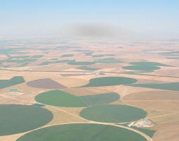
Satellite imagery constitutes a great opportunity to visually illustrate the territorial diversity of the European Union, highlighting the elements of relief, hydrography, land use and structure of the territory beyond the national borders, thus creating a connection between common elements and problems of a cross-boarder nature. The Unité de recherche en environnemétrie et géomatique of the catholic University of Louvain-la-Neuve has produced an interactive program 'The European Union, a novel perspective', which includes a satellite map of Europe based on a year synthesis of VEGETATION data, a sensor onboard of the SPOT 4 satellite. The program provides a timeline illustrating the various stages of the construction of Europe, gives access to a calendar displaying the life cycles of the principal earth observation satellites visualizing the launch dates and states of 135 satellites and sensors as well as applications, and explains remote sensing, data acquisition and processing.
| Contact information | n/a |
|---|---|
| News type | Inbrief |
| File link |
http://telsat.belspo.be/beo/en/europe-index.htm |
| Source of information | TELSAT |
| Keyword(s) | satellite data, ENVISAT, SPOT |
| Subject(s) | METHTODOLOGY - STATISTICS - DECISION AID |
| Relation | http://www.emwis.net/topics/fol573816 |
| Geographical coverage | Europe |
| News date | 20/03/2007 |
| Working language(s) | ENGLISH |
