 you are not logged in


![]()
![]()
![]()
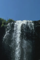
 Protection of the Jeita-Spring
Main problems of the water sector in Lebanon are the insufficient management and the deficient protection of the groundwater resources. In the metropolitan area of Beirut approximately 1.9 million residents depend on the drinking water supply of the Jeita-Spring, located approximately 13 km northeast from the city center of Beirut. The groundwater aquifer in the catchment area of the Jeita-Spring is endangered by numerous pollution sources, in particular by sewage water. Furthermore the water distribution system is antiquated and approximately 4.5 km west of the Jeita-Spring the sewage-treatment plant in Dbaye is not able to intercept the pollution sufficiently. The water supply of Beirut thus is acutely threatened.
Project partners are the Council for Development and Reconstruction (CDR), the Water Establishment Beirut Mount Libanon (WE-BML) as well as the Ministry of Energy and Water (MoEW). Other project partners and public authorities (such as Ministry of Public Works, Ministry of Environment and municipalities in the catchment area) will be integrated into project activities according to requirements. It is the first suchlike project for groundwater protection in Lebanon and thus has an important pilot and signal function for the water and environmental sector.
Technical Cooperation with Lebanon
Project-No.: 2008.2162.9
Project-ID: 1048
Project contributions:
Partner:
Council for Development and Reconstruction (CDR)
Water Establishment of Beirut and Mount Lebanon (E.B.M.L.)
Republic of Lebanon. Ministry of Environment (MOE)
Contact:
Dr. Hans Günter MyliusPhone: +49-(0)511-643-2359 Fax: +49-(0)511-643-3661 E-Mail: Hans-Guenter.Mylius@bgr.de
| Project number | 2008.2162.9 | ||
|---|---|---|---|
| Subject(s) | HYDRAULICS - HYDROLOGY , MEASUREMENTS AND INSTRUMENTATION , METHTODOLOGY - STATISTICS - DECISION AID , NATURAL MEDIUM , PREVENTION AND NUISANCES POLLUTION , RISKS AND CLIMATOLOGY , TOURISM - SPORT - HOBBIES | ||
| Geographical coverage | Lebanon | ||
| Budget (in €) | 0 | ||
| Programme | BGR | ||
| Web site | http://www.bgr.bund.de/EN/Themen/Zusammenarbeit/TechnZusammenarb/Projekte/Laufend/Asien/1048_2008-2162-9_Libanon_JeitaQuelle_en.html | ||
| Objectives | The project planned by BGR takes place in parallel to a project ofKfW with the same title. KfW project envisages the construction of sewage-treatment plants and collectors in the catchment area of the Jeita-Spring. Both projects conduce to the decline of the pollution of surface- and groundwater. The main reason for the contamination of the Jeita-Spring is the so far not regulated collection and treatment of sewage water in the catchment area of the Jeita-Spring. In line with the German Technical Cooperation measures it should be attempted to integrate aspects of water resources protection into the planning of projects for sewage water purification as well as into other domains of landuse planning |
||
| Results | Task 1 BGR will assist the partners to prepare the hydrogeological part of the EIA. Currently EIAs in the wastewater sector don't follow well defined rules and regulations. Therefore the BGR project has established a guideline for environmental impact assessments in the wastewater sector. Treated wastewater reuse may provide additional water for irrigation when discharge of springs is not sufficient. Therefore the Ministry of Energy and Water is currently in the process to establish regulations for treated wastewater reuse. The BGRproject has prepared a guideline for treated wastewater reuse which specifically addresses the following issues :
The project also prepared a best management practice guideline for treated wastewater and sludge reuse.
Task 2 Groundwater protection zone 2 is delineated using groundwater vulnerability mapping. Two methods specifically developed for karst areas were selected: EPIK (Epikarst, Protective cover, Infiltration, Karst network) and COP (Concentration of flow,Overlying layers, Precipitation). For this purpose soil and karst feature mapping had to be conducted. The groundwater vulnerability maps will be prepared in cooperation with the University of Göttingen/Department of Applied Geology. In order to be able to propose water resources management options in the catchment, a WEAP model (Water EvaluationAnd Planning System) is being established. Base data for all components of the water balance are being collected through new monitoring stations provided by the project (meteorological stations, surface water runoff gauging stations, acoustic doppler current profiler). Task 3
Task 4 The drinking water purification plant at Dbaye, which is, like many of the water supply facilities very old (built in 1896), currently only consists of chlorination and sand beds and is therefore not able to eliminate organic contaminants such as pesticides or hydrocarbons. An extension of the treatment plant is not possible due to lack of space. If hydrocarbons were present in the raw water, there would even be a risk of the formation of chlorinated hydrocarbons through treatment. The conveyor bringing water from Jeita to Dbaye is partly 140 years old and leaky. The canal is partly open and people have drilled into the canal. Thus there is also a high pollution risk emanating from the conveyor itself and the treatment. The tunnel drilled through the mountain north of Dbaye is too small and limits the capacity of the water supply system to 255,000 cubic meters per day. A damage to the tunnel by tectonic movements or earthquakes would have disastrous consequences. Not just the quality but also the quantity of water provided by the conveyor is more and more becoming a problem. In December 2010 water supply from Jeita and Kashkoush was critically low. A solution to overcome periods of water shortage would be to build one or more dams. The project is looking into such and other water resources management options for the project area. |
||
| Period | [16/06/2009 - 31/12/2013] | ||


